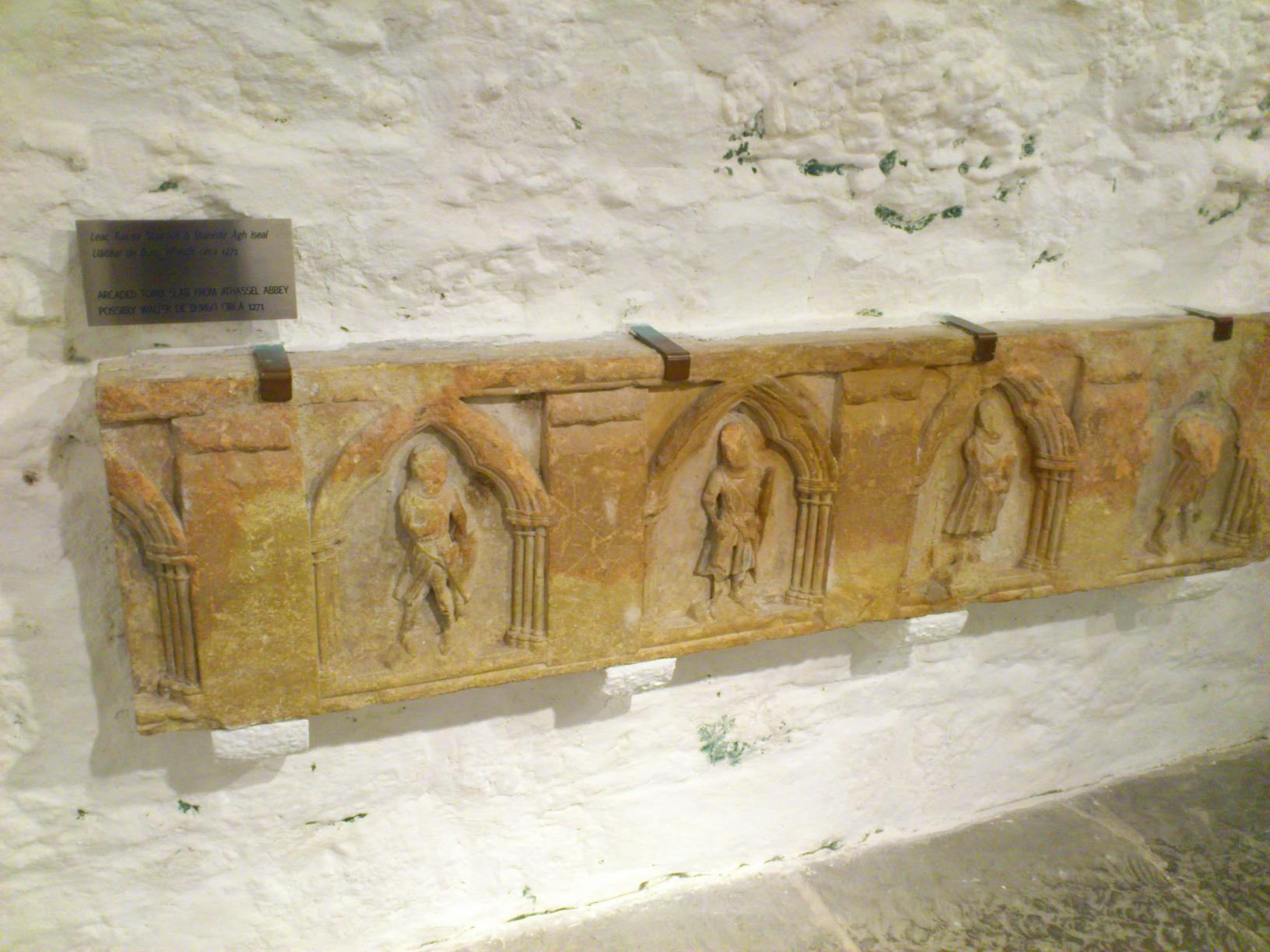
Walter de Burgh, 1st Earl of Ulster

Tomb slab from Athassel Priory.
Possibly the tomb of Walter de Burgh, 1st Earl of Ulster.
On display at
Rock of Cashel.
Photo 2013.
See
full size.
See
wider shot
and
notice.
Walter de Burgh, 1st Earl of Ulster,
born c.1231.
See
wikipedia.
Founder of Galway:
He established the walled Norman town of
Galway
around Galway Castle.
There were repeated attacks on Galway town by the Irish in the 13th century.
He was cr Earl of Ulster 1264.
He died in
Galway Castle, 1271, age c.40 yrs.
He was
bur
Athassel Priory
(or Athassel Abbey),
SW of Cashel,
Co.Tipperary
(see
street view
and
other side of river).
He
had issue:
Richard de Burgh, 2nd Earl of Ulster,
"The Red Earl", born 1259.
See
wikipedia.
He
succ 1271.
The
Hall of the Red Earl, Galway,
was built in the late 13th century.
In later life he retired to Athassel Priory.
He
died Athassel Priory, June 1326, age 67 yrs.
He was bur Athassel Priory.
He had issue:
- Eleanor de Burgh.
She
mar Thomas de Multon, Lord Multon of Egremont.
They
had issue:
- Elizabeth de Multon.
GORMANSTON in [Complete Peerage]
shows her as dau of the above.
She
mar 1stly to Robert Harington.
She mar 2ndly to Walter Bermingham
and had issue.

- Elizabeth de Burgh.
She mar Robert I the Bruce, King of Scotland
and had issue.

- John de Burgh, born 1286.
He mar 1308 to Elizabeth de Clare
[grand-dau of Edward I
and descendant of Aoife Mac Murrough].
He died in Galway, 1313, age 27 yrs.
They had issue:
- William de Burgh, 3rd Earl of Ulster, born 1312.
He mar
Maud Plantagenet
[descendant of Henry III].
He was assassinated in 1333, age 21 yrs.
They had issue:
-
Elizabeth (Isabella) de Burgh, Countess of Ulster.
She mar
Lionel of Antwerp, Duke of Clarence
and had issue.

- Joan de Burgh.
She mar 1stly, 1312, to Thomas Fitzgerald, 2nd Earl of Kildare
and had issue.

2nd Earl died 1328.
She
mar 2ndly, 1329, to John D'Arcy, 1st Baron D'Arcy
and had issue:
- Elizabeth D'Arcy,
mar 1346 to James Butler, 2nd Earl of Ormond
and had issue.

Galway Castle was in the S corner of the walled city
(near the Hall of the Red Earl).
It seems to be gone on the 1583 map.
It is gone on the 1651 map.
Nothing of it survives above ground.
Some remains of it were found beside the Hall of the Red Earl
in the 1997 excavations, but were covered up again,
apparently under the new Custom House building on Flood St.

The site of Galway Castle ("A")
on
1583 map.
The castle seems to be gone.
The map says "A" is
"the place for the citadel"
(rather than
"the citadel").
S is approximately up.
This is the S corner of the walled city,
near
Spanish Arch.
The
Hall of the Red Earl
had fallen into ruin by 1556.
It is shown roofless on the 1651 map.
Remains of it were discovered during excavations in 1997.
The remains can now be seen on the SW side of Druid Lane, Galway
(see
map
and
street view).
This is now the oldest surviving structure inside the walls of Galway.
See
Flickr photos.

Hall of the Red Earl, Galway, shown in ruins on
1651 map.
From
here.

Wider shot of
1651 map
showing location of Hall of the Red Earl ("75").
It is in the S corner of the walled city,
near Spanish Arch.
Galway Castle is clearly gone by this time.

The ruined Hall of the Red Earl
shown in a
3D computer model based on the 1651 map.
See
02:55
in
2014 video
from
RealSim Movies.

Remains of the Hall of the Red Earl, Druid Lane, Galway.
See full size.
From here.

Remains of the Hall of the Red Earl, Druid Lane, Galway.
See full size.
From here.


